
Overview
Lerne das seit 2008 existierende und 2023 neu aufgelegte "Schweizer Taschenmesser" unter den Flugsportprogrammen kennen:
- Flugbuch mit kombinierbaren Filtern und freier Sortierung
- Dokumentation nach §120 LuftPersV, auch für Tandem
- Anschluss nahezu aller neuen und alten Varios
- vollautomatisches Auslesen und Fluganalyse
- über 700 Statistiken
- frei kombinierbare, komplexe Filter
- Import/Export von Flugbuch und Bildern, Wegpunkten, Routen und Lufträumen
- immer aktuelle Lufträume fürs Vario dank XContest-Integration
- ausgefeilte Hike&Fly-Dokumentation
- Synchronisation über mehrere Rechner (OneDrive, DropBox, USB)
- Ortsverwaltung mit Fluggebiets-Editor
- FAI- und Routenplanung (auch offline)
- DHV/XContest Upload
- Thermikanalyse
- integrierter Bildbetrachter
- Referenzflug-Datenbank
- Geräteverwaltung mit fälligen Checks (auch für Medicals und Checkflüge)
- Volle Datenautonomie: Anders als bei Online-Flugbüchern bleiben Deine Daten ausschließlich bei Dir, statt Händlern oder Datensammlern als Rohmaterial zu dienen!
Informiere Dich über alle Programmfeatures auf den Anleitungs-Seiten (unter Support/FAQ) und im Online-Handbuch
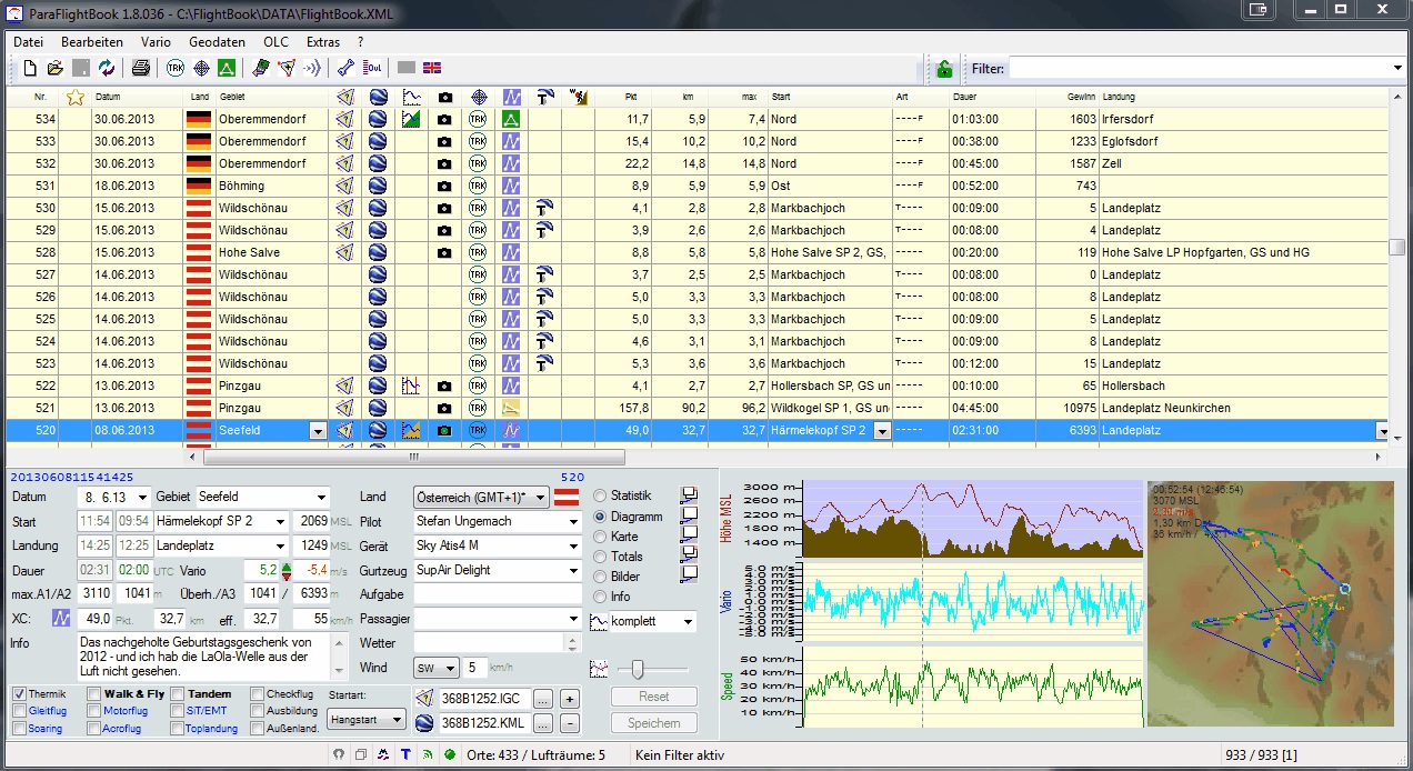
Flight log
Betrachte Dein ganzes Fliegerleben auf einen Blick. Du kannst Flüge von Hand eingeben, automatisch aus dem Internet herunterladen (DHV, Leonardo, SeeYou-Cloud, Komoot...), gruppenweise mit der Maus ins Flugbuch ziehen oder mit nur einem Klick ein ganzes Flugwochenende aus dem Fluginstrument holen. Dabei werden auch Messfehler ausgeglichen, Windenstarts erkannt, Flugbeginn und -ende herausgefiltert und sogar auf Wunsch Flüge gesplittet, wenn das Instrument dazwischen nicht ausgeschaltet worden ist.
Die Erkennung von Startplatz und Fluggebiet, Land oder Zeitzone erfolgt automatisch. Zu jedem Flug kann eine Vielzahl von Daten erfasst werden – wahlweise auch direkt in der Liste. Filtern Sie Flüge von Hand oder durch Doppelklick auf die gewünschte Information, bearbeiten Sie mehrere Flüge auf einmal, und gestalten Sie die Liste nach Ihren Vorstellungen.
Stelle ein eigenes Layout aus Informationsfenstern zusammen, das beim Start wieder geladen werden kann. Verwende so viel Flugbücher wie Du willst – für die Familienmitglieder, aber auch für eine Vereinsmeisterschaft oder als Datensammlung für die Fluggebietsanalyse. Selbst wenn Du nebenher noch Flugzeuge fliegst, hilft Dir das Programm – denn es kann auch FCL-JAR-Flugbücher mit Mustern, Block- und Rollzeiten führen.
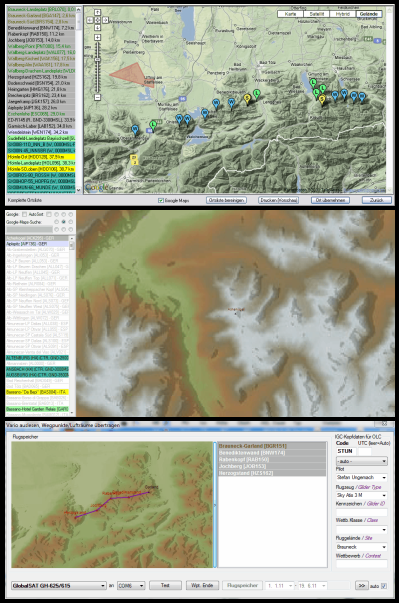
Waypoints and maps
New philosophy: ParaFlightBook treats waypoints, launch sites and airspaces together as “sites” – just like the pilot who only says “I’d like to fly there“.
You can open as many map-enabled site windows as you like – and copy items per Drag&Drop between them. Each window knows all kinds of common formats: WPT, CUP, KML, OpenAir, SeeYou… – and of course you can drag such a file just on the programs window as well.
A double-click in the map creates an editable waypoint; GeoServices in the background retrieve altitude, country and even a naming suggestion. Airspaces are drawn with the mouse – so it’s also easy to store i.e. dangerous lee areas and to bring them on your device.
A global GeoData collection learns from flights and supports itself the automatic recognition of site, launch and landing places.
Complete sites can also be directly loaded in the map-enabled vario dialog to be sent to the device – in one step; the splitting into waypoints and airspaces is handled internally. An AutoSort-feature makes it easy to create sub-sites for your own XC plans.
The export into all supported formats is also possible. ParaFlightBook is a most comfortable editor for all kind of flight-related kinds of GeoData. Some common use cases are:
- filter an OpenAir file by floor and glider relevance, or combine several of them
- prepare yourself for holiday with a customized site including even thermal spots from the TSP
- convert GeoData while checking what’s in there
- check the quality of waypoint lists
- share site descriptions with your friends
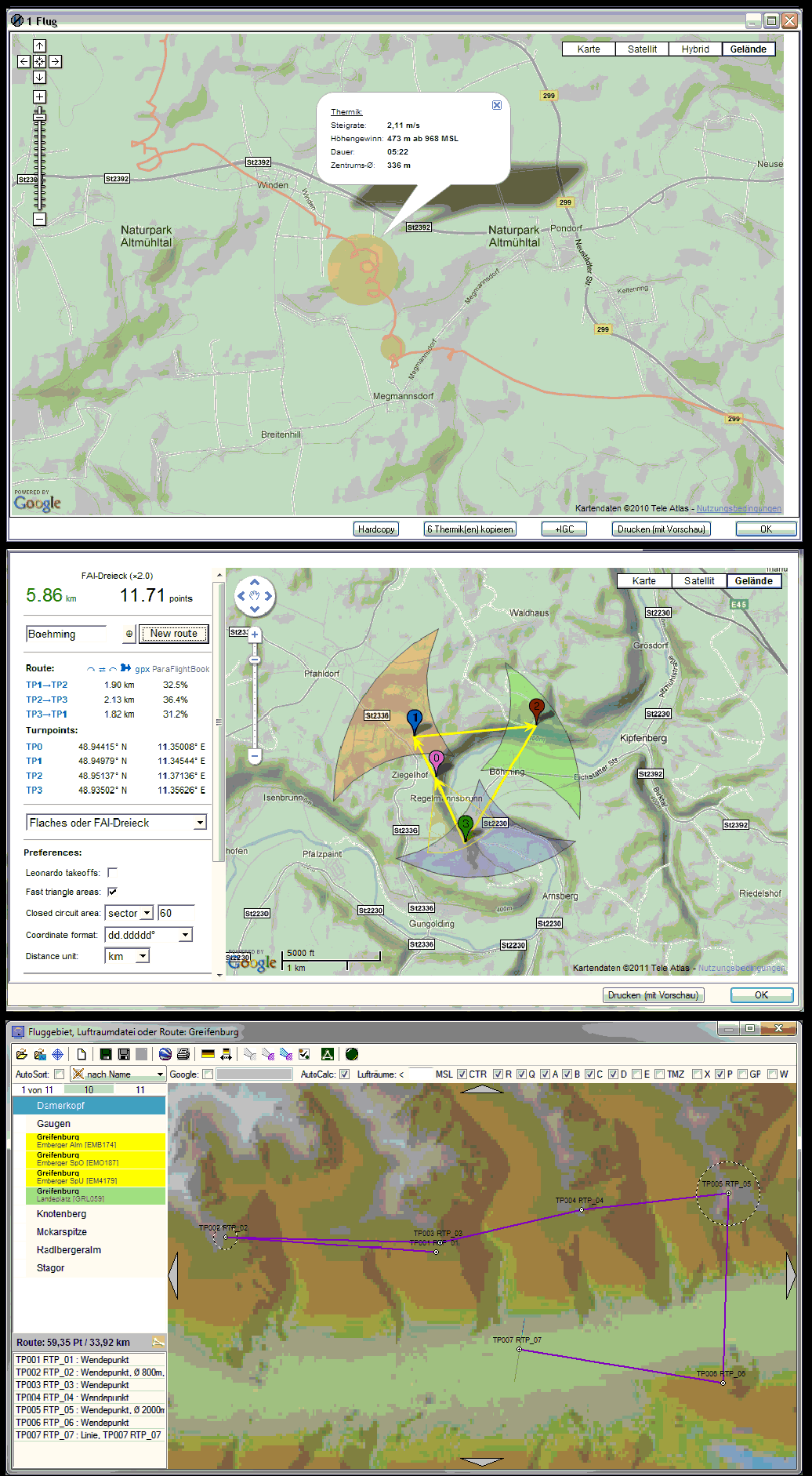
FAI and thermals
ParaFlightBook besitzt einen Offline-FAI-Routenplaner mit XC_Optimierung. Zeichnen Sie eine Route mit laufender Berechnung der XC-Punkte, fügen Sie per Drag&Drop Orientierungspunkte und Lufträume hinzu, speichern Sie die Route und laden Sie sie direkt auf Ihr Fluginstrument. Selbst die Erweiterung für Wettkämpfe (Zylinder, Startgates…) ist möglich.
Zusätzlich kann die ThermiXC-Seite von Bernd Gassner im Browser oder einem Programmfenster verwendet werden (die zweite Variante erlaubt das vollautomatische Übernehmen einer geplanten Route im XCTSK-Format in die interne Planung). Dieses hervorragende FAI-Planungstool macht von allen aktuellen Möglichkeiten und Datenquellen Gebrauch und stellt eine gute Dokumentation zum Thema Online-Flugplanung bereit, die auch schon im DHV-Magazin veröffentlicht wurde.
Eine innovative Thermikanalyse ermittelt nicht nur das Steigen aus Tracks, sondern rechnet auch deren Versatz auf die Geländehöhen zurück und findet die Abrisspunkte. In das kartengestützte Analysefenster können Flüge direkt aus den DHV- oder XContest-Listen heruntergeladen oder IGC-Dateien per Drag&Drop hineingezogen werden. So entstehen viel gezieltere Thermikkarten als durch das wahllose Übereinanderlegen Tausender Flüge. Diese Thermikkarten können gedruckt, gespeichert und an Fluginstrumente ausgeliefert werden.
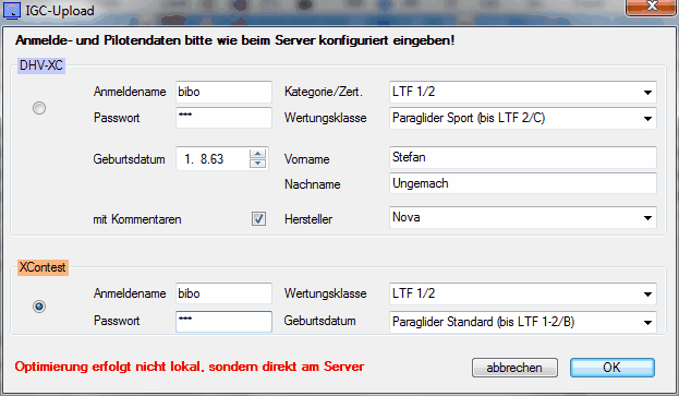
XC and OLC
Eine interne XC-Optimierung mit einstellbaren Faktoren berechnet nicht nur Deine Flüge, sondern läuft auch beim Planen von Routen oder Aufgaben mit. Die Aufgabenart mit dem besten Ergebnis wird beim Flug hinterlegt.
Flüge können sowohl zum DHV-XC als auch zu XContest direkt hochgeladen werden – einzeln oder gruppenweise. Die unterschiedlichen Klassenregeln für 2012 werden berücksichtigt.
Nach dem Auslesen des Fluginstruments sind die übernommenen Flüge bereits markiert und können direkt optimiert und hochgeladen werden.
Flüge vom DHV-XC können direkt ins Flugbuch oder in - dies sogar im Stapel unter Verwendung der auf dem Server eingestellten Filter - eine Referenzdatenbank für Vergleichs-, Planungs- oder Vereinszwecke heruntergeladen werden.
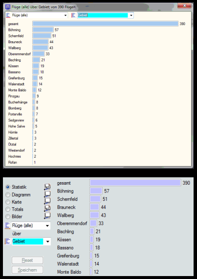
Statistics
Über 700 filterbare Statistiken und Totals können sowohl im Infobereich als auch in abkoppel- und andockbaren Fenstern - letztere in beliebiger Menge gleichzeitig - angezeigt werden.
Die Statistiken umfassen unter anderem:
- Flüge (alle, >4 Minuten, ab 1/2h, ab 1h)
- Flugstunden
- Flugarten (H&F, Acro, Tandem, Ausbildung und SiT)
- Flugtage und -wochenenden, Fluggebiete und Länder
- maximale Höhe, maximale AGL, Startüberhöhung
- H&F-Höhenmeter
- maximales Steigen/Sinken
- Groundspeed, Flugdauer, XC-Punkte/-km, Strecken-Kilometer (maximal/Durchschnitt)
über:
- Jahr, Fortschritt (Jahresvergleich zum aktuellen Datum), Saison, Fliegerjahr (gerechnet vom ersten Flug)
- Monat, Jahresmonat, Wochentag
- Startzeit oder -art
- Fluggerät/Gurtzeug, Hersteller, Modell und Klasse
- Fluginstrument
- Fluggebiet, Land
- Pilot, Passagier
Für alle Statistiken wie auch für die Anzeige können Filter definiert werden. Schnellfilter entstehen durch Doppelklick, komplexere Ausdrücke ("alle Flüge mit Tandem und H&F, aber nicht von Böhming oder Oberemmendorf, bei denen ein Ozone-Schirm verwendet wurde") werden direkt ins Filterfeld eingegeben.
Graphs and images
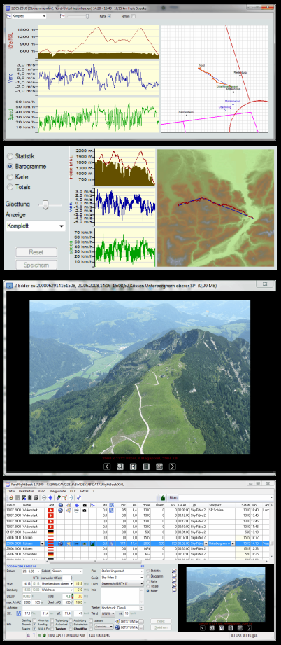
Für Flüge mit GPS-Daten stehen vielfältige Diagramme in verschiedenen Kombinationen zur Verfügung, die auch zur genaueren Untersuchung, beispielsweise von Luftraumverletzungen, in ein skalierbares Fenster herausgezogen werden können. Sogar ein manuelles Korrigieren der Start- und Landezeiten im Diagramm ist möglich.
Die gefilterten Daten des Flugbuchs können in verschiedene Reports (Tandem, Fluglehrernachweis, FCL/JAR etc.) ausgegeben und gedruckt werden. Die Reports sind über XSL konfigurier- und beliebig erweiterbar.
ParaFlightBook enthält einen eigenen Bildbetrachter, in den Bilder sowohl als Referenzen als auch als Kopie, für die Ablage auf USB-Ticks wahlweise sogar automatisch herunterskaliert, per Drag&Drop gezogen werden können.

Hike & Fly
Wer zum Start läuft, hat mehr als nur den Flug erlebt - und möglicherweise sogar auf diesen verzichtet. All das kann auch verwaltet werden.
Zu jedem Flug kann bei gesetzten H&F-Flag die gelaufene Höhe manuell erfasst werden (ohne diese Angabe wird die Differenz zwischen Start und Landung als Wanderhöhe für die Statistiken angenommen). Ein reiner Hike kann manuell angelegt werden und wird gesondert unterlegt.
Zu jedem Flug können mehrere GPX-Tracks hinzugefügt werden. Diese werden in Google Earth gemeinsam mit der Flugstrecke in 3D dargestellt, so dass der ganze Tag nacherlebt werden kann. Das ist auch für mehrere Tage möglich: Das Beispielbild zeigt den kompletten Verlauf eines zweitägigen H&F-Events.
Geräte und Checks
All Deine Schirme, Gurtzeuge, Retter etc. werden im Flugbuch verwaltet. Wenn Du mehrere Schirme des gleichen Modells hast, kannst Du sie unterschiedlich benennen. Mit Hilfe eines Aktiv-Kennzeichens bestimmst Du, welche Geräte Dir bei der Flugerfassung angeboten werden.
Fällige Checks werden automatisch überwacht, und Du siehst jederzeit, ob bei Deinen Geräten alles im grünen Bereich ist, demnächst Checks anstehen oder gar welche überfällig sind.
Zu jedem Schirm und Gurtzeug wird Dir angezeigt, in welchem Zeitraum Du es verwendet hast, wie viele Starts und wie viele Flugstunden es hinter sich hat. Das hilft beim Verkauf.
Auch Deine Medicals (z.B. für Tandem/Österreich oder FCL/JAR) kannst Du in der gleichen Weise verwalten und rechtzeitig an deren Ablauf erinnert werden. Und um fällige Tandem-Checkflüge wie auch die Einhaltung der 90-Tage-Regel kümmert sich das Programm gleich mit.
Eine Zusammenfassung kann sofort am Bildschirm angezeigt oder als PDF gedruckt werden.

